On the Heels of Lewis & Clark
May 1, 2011
Remember learning about the Lewis and Clark Expedition in history class? In 1803 the two intrepid explorers left Clarksville, IN tasked by President Thomas Jefferson with locating “…the most direct and practicable water communication across this continent for the purpose of commerce.” The pair didn’t reach the Pacific Ocean in Astoria, OR until 1805.
Brent Phelps is a photographer and explorer who intermittently photographed the entire Lewis and Clark route between 1997 and 2002. He documented the route, creating panoramic photographs with a determination that would have made Jefferson proud.
Phelps honed his photographic talent in the West over many years—first beginning with a Kodak Brownie as a teenager in Southern Illinois. “The camera was an eighth grade gift from my parents, and I remember taking it on our school bus trip to St. Louis,” he says. Amazingly, Phelps still has the camera, but has segued into 35mm and large format color over the years.
During his undergraduate days at Southern Illinois University Phelps majored in journalism, but changed his major after he had a summer public relations job at a school for mentally challenged children. There, he says he watched the staff photographer “perform magic in the darkroom…and the photo bug bit me.” As a result of experiencing this, Phelps graduated with a degree in photography, before pursuing graduate school at Arizona State University [ASU].
Besides the faculty at ASU, Phelps says he had other photographic influences, including Walker Evans, Timothy H. O’Sullivan, William Henry Jackson and Carleton Watkins. “Those men were pioneers associated with historic and impressive medium format and view camera work in the South and West,” he says. After receiving a Master of Fine Arts in photography from ASU, Phelps taught English and photography at Hopi/Navajo reservations. “I didn’t produce much work at that time,” he recalls. “After graduate school I was burnt out and needed a break.”
Later, while teaching at Sam Houston State University, Phelps began working in large format. “I needed a change from 35mm,” he explains, “and I also started shooting color, experimenting with urban environments in the Houston area. I later got involved photographing rural landscapes.”
In 1980 he received a National Endowment for the Arts Fellowship [NEA] to produce Housescapes, a series of portraits chronicling rural Texas farmhouses. “There were no people in the series,” he says, “but there were dogs and farm animals. All were done in 4 x 5 color. The work was never published, but was exhibited in several cities. I had just arrived at Denton to teach at the University of North Texas (where he is still on the faculty), when I heard from NEA that I was awarded the fellowship. It was quite a surprise. I didn’t think I had a chance.”
Westward Bound
Throughout the 1980s and ‘90s Phelps developed a love for Montana landscapes while in the region shooting for Wilderness Press and magazines like Shooting Sportsman. One day in 1996, while photographing near Ft. Benton, MT, he parked by a historical sign referencing Lewis and Clark. Their expedition bicentennial was approaching. Phelps was already familiar with many areas the duo had passed through, and it was this chance encounter that inspired his Lewis & Clark Trail project.
Getting the project underway, however, took a lot of research, patience and imagination. “Finding funding was the hardest part,” Phelps says. “Few agencies I applied to would accept applications from individual artists. Early on in the project the University of North Texas and the Amon Carter Museum in Fort Worth, TX formed a consortium and applied to NEA, but that application was denied.
“I was a awarded several small faculty research grants through the university where the development office did an outstanding job of helping me apply for financial help. The number of awards that evolved were fewer than I hoped, and I felt it was important to use some of my own money because I had so much enthusiasm already invested,” Phelps says. Eight companies, including Wells Fargo, Denton County and other anonymous donors helped the museum fund the exhibition.
The Mission
Phelps researched his mission based on the Gary Moulton editions of the Lewis and Clark journals, which he says are the most accurate and complete to date. “Moulton’s footnote system was very helpful in getting me in the approximate vicinities of the actual sites I decided to photograph. Early on I met with Bob Bergantino, an advisor to Moulton, who has corrected known errors in the latitude and longitude readings of the expedition sites mentioned in the Lewis and Clark journals. Bob was so impressed with my project design that he printed his research onto a disc and gave it to me. His calculations were a huge help.
“From the beginning, I decided to use a GPS device to record the latitude and longitude of the camera for each shot. Previous photographic surveys of the historic route sought to depict a romantic, unblemished wilderness and covered only sites that remained as they might have been 200 years ago. Instead, I photographed the route as it looks today, including cultural evidence now existing in the landscape. In some pictures, areas look relatively unchanged, but other images include the cultural clutter of our time such as Bump and Run Raceway, Cannon Beach and Trojan Nuclear Power Plant.”
For capturing images of Lewis and Clark’s route, Phelps used a Linhof Technorama panorama camera with 120 medium format film. The camera is an older model with a non-interchangeable Schneider Super Angulon 90mm f/5.6 lens.
“GPS readings to position the camera added another layer of veracity to the project, because Thomas Jefferson had instructed Meriwether Lewis to record this information at the confluence of rivers, geographical formations, Indian villages, etc.,” says Phelps. “I used satellite technology, while Lewis and Clark used the artificial horizon and a spring-wound chronometer. I see the project as a historical record. Camera coordinates for each photograph could be used in the future for a follow-up survey.”
Despite his background in landscape and social-documentary photography, Phelps says he began the project with a “second grade knowledge of history” and did a lot of research to get up to speed. “I was also naive and believed I would be able to find the ‘actual spots’ described in the Lewis and Clark journals, even though the actual locations of most of the expedition sites are highly debated by scholars.
So it’s difficult to say that any given site I photographed is the authentic spot of history, short of finding archeological evidence. Some geographical formations are the same, but I realized that things had changed during two centuries and determined that being in the vicinity was close enough.”
As it evolved, the project became a process of discovery. “I believe I shared a similar curiosity with Lewis and Clark,” Phelps says. “Like them, I went there to see what the land looked like. I had not visited most of the sites previously, so discovering them after reading the journals was quite an exciting prospect.” Still, the weeding-out process over thousands of miles of once- pristine landscape was prodigious.
“The picture-editing process was sizeable, but fascinating,” Phelps says. “I pulled just under 400 images to show Barbara McCandless, curator of the exhibition of my work at the Amon Carter Museum. We reduced 400 to 100, and she did the final edit to 66 images in the exhibition. It was a satisfying dénouement from about 50,000 miles of exploration to achieve the project.” Fittingly, passages from the Lewis and Clark Expedition journals provided captions for Phelps’ photographs.
Barbara McCandless comments of the chosen photographs, “Through Phelps’ incredible attention to detail, his use of ironic juxtapositions and his emotionally evocative treatment of color, he draws the viewer into the scene. These historic sites… allow visitors to travel the Lewis and Clark Trail vicariously in an experience of awe and discovery.”
Brent Phelps’ work can be viewed at www.brentphelps.com.
Lou Jacobs Jr. is the author of 30 how-to photography books, the latest of which is How to Start and Operate a Digital Portrait Photography Studio (Amherst Media). He has taught at UCLA and Brooks, is a former president of ASMP national, and has also written and illustrated numerous books for children. He enjoys shooting stock during his travels in the U.S. and abroad.
Related Articles
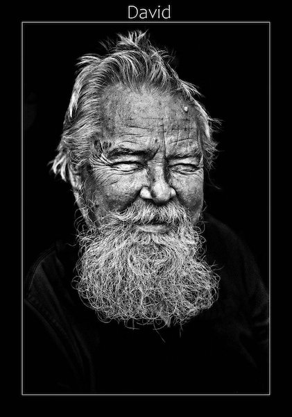
Capturing Humanity: Crombie McNeill’s Portraits of the Homeless
July 19, 2023
When Canadian photographer Crombie McNeill first started his career in photojournalism in the early 1960s, a peer suggested that he visit the Union Mission and take some portraits of the homeless people there in order to build his portfolio. Based in Ottawa, Canada, for the entirety of his career, McNeill entered the Union Mission skeptical that anyone would allow him...
More »
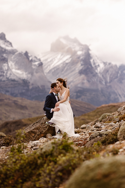
From the Rockies to Patagonia: Elopements that Go the Extra Mile
June 28, 2023
With the eye of an eagle, the endurance of a mountain goat, and the joy of a wildflower in the breeze, Chilean-born Andrea Enger was destined to become a photographer of adventure elopements. She has overcome her share of challenges as both a Latina woman and immigrant, pioneering into photography with her heart set on a life of creativity. Now...
More »

Robyn Lindemann Finds the Light in her Darkening World
February 27, 2023
Robyn Lindemann had to give up her wedding business after being diagnosed with retinitis pigmentosa. Now she's traveling the world before she goes blind.
More »